A group hike to Golden Throne is on today's agenda, unless Little Adventures Jim is too hungover from last night's 3.2% "piss-water" beer. I guess I don't get it. In a state where talking heads look the other way regarding Polygamy and Prepubescent wives, Prohibition, of all things, is enforced with Sadam-like authority. Sadly, Utah's arbitrary, antiquated, and nonsensical liquor laws mandated us to wash down thick crust pizza with little more than carbonated water, which is totally unAmerican, if not downright dangerous (insert frown face here).
Now for Part II of "Upper Muley Twist."
As a commenter noted on the previous post, it was a long, long, l-o-n-g drive from Camp Red Rock to the Upper Muley Twist trailhead... two hours, to be exact, but extremely scenic hours which, in my mind's eye, is time well spent.
Notem Road was mostly hard-packed clay, allowing us to motor along at 50 to 60 mph. However, be sure to keep in mind that you wouldn't make a hundred yards if you got caught in a rainstorm. This kind of clay quickly becomes quagmire-ish when mixed with water, as in, "Caution, Sticky when Wet."
Notem parallels the mind-blowing, almighty heave of Waterpocket Fold, sometimes within a stones-throw of its slot-canyoned, sandstone base. It undulates in folds of red and white rock, with the occasional patch of baby-poop yellow (okay, yellow ocher if you are reading this over scrambled eggs :). Notem gave me a real sense of appreciation for the magnitude of the Waterpocket uplift, and a surreal sense of the powerful underlying forces it took to make it happen. I couldn't help but wonder if one day technology might allow us to harness other forms of "energy" (besides oil) from below Mother Earth's crust, maybe use it as a supplement to Old Sol. Imagine the earth as one ginormous capacitor with millions of piezo-cords plugged in (Piezoelectricity is electrical energy produced from mechanical pressure). I digress…
Notem eventually gave us the Burr Trail option… a serious series of switchbacks that serpentine (say fast three times) up a rare opening in Waterpocket big enough for a road. Even then, it took considerable imagination, determination, and dynamite. The Burr Trail is not a four wheel drive road so don't be deterred by its reputation if you happen to be traveling by car. Car, yes. Motorhome or Fifth Wheel, No!!!! The top offers a great perspective. It's a challenge to wrap one's mind around Waterpocket's eroded topography and bursts of color in such an otherwise desolate-to-the-point-of-yawning landscape. What an unfortunate surprise to Mormon pioneers, so close the Promised Land, yet so far, far away.
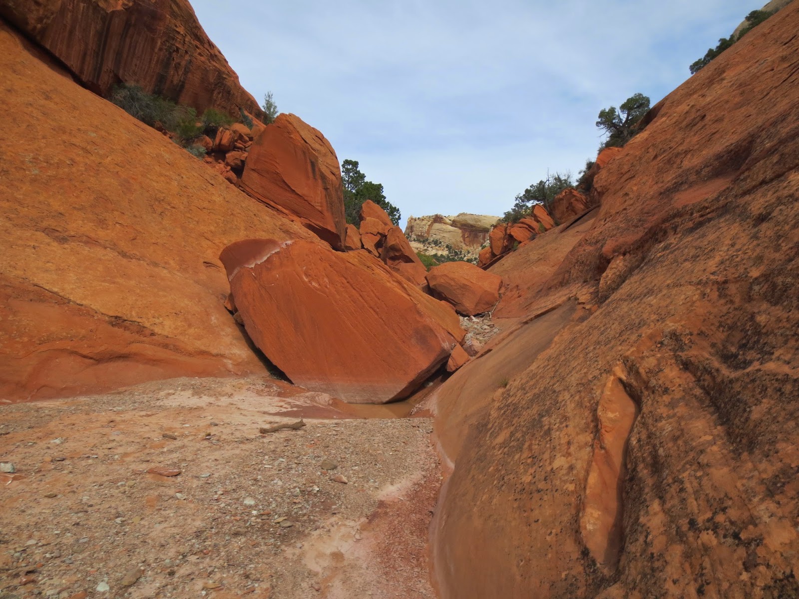
A few miles beyond Waterpocket's top-out, a battered sign pointed the way to Upper Muley Twist, recommending four wheel drive and high clearance. We followed what was basically a stream bed, dodging boulders and other obstacles that made us doubt how far we could go. The loop hike was already going to be nine or ten miles and I wasn't really up for adding to that number, thus I kept telling Maikel to go for it, that, "By God I could get Goldie in here," and other quips that attacked his Manhood, if not gender. Needless to say, we made it to the trailhead—bumped and bruised and ready to get out of the truck and hike.
Our plan was to do the loop, barring injury or fatigue. A sign at the trailhead said 9 miles, but someone had put an X through that and scratched "10" beside it. They proved to be right, too, as Maikel's GPS read slightly over ten when all was said and done.
The first mile was wide and easy, just a stroll up the creek bed. Beyond that it gets more interesting by the mile… narrowing and delighting with red rock to the left and white rock to the right, abruptly demarcated by a dry wash. It had it's moments of exposure and false cairns that led us out of the way, but all-in-all not as airy or scary or exposed as we expected… just long with occasional scrambles. We had the option to do the loop either way, but chose to do it clockwise…which I recommend as I think it would be slightly easier to hike and route-find. Clockwise meant staying in the canyon going out, and coming back above canyon, on a ridge that gives incredible views of the fold as well as the route below that was just hiked.
We were pleasantly surprised at finding nearly 20 arches, some of them rivaling anything we've found in Arches National Park. Enough talking, let's get to the photos…
Peace Out,
Mark and Bobbie enjoying the RV Gang and Postcards in Utah's Slot Canyon Country.


Loved all the arches...I did not find any thing like the striped final wonder in Arches. Just beautiful!
ReplyDeleteBucket list hike for me. Kids know my ashes go somewhere in view of the Strike Overlook and the Waterpocket. Patience rewarded with your photos. Thanks
ReplyDeleteAbsolutely stunning typography. Great photos. Thank you for sharing. As I looked at these images, I kept saying "Man, there are times when A LOT of water has ripped thru those slots and other canyons.
ReplyDeleteWhat a hike! Breathtaking pictures! The colors are just super and so many arches. Gotta see this in person. Loved the Golden Throne really looking forward to your fabulous pictures there. So knowing the LDS "attitudes" why didn't you bring along 24 packs x 7 or 8 for your pizza.
ReplyDeleteLooks like it was well worth the drive, we'll have to check that baby out next time we're in the area...though a bit closer I suppose! Looks like you probably managed to keep your feet dry!
ReplyDeleteDefinitely worth the drive!! I need to see all the arches. Gorgeous rocks! Great photos:)
ReplyDeleteUtah liquor laws are somewhat bizarre but have improved a LOT since the 2002 Winter Olympic Games.
ReplyDeleteUtah's 3.2% beer becomes 4.0% when measured by "normal" standards. A six-pack of Utah beer has roughly the same alcohol content as five beers from another state. Beer of the 3.2 type is available at supermarkets and convenience stores, but full-strength beer can only be bought at state liquor stores — at a hefty price.
Don't buy the cheap stuff, pay for the 'real deal' or drink more.
I lived with my family in Utah for ten months in 1977. Quickly learned to purchase wine, red goes great with pizza and bring it with us. Usually with no hassle. Friends would drive up to Wyoming and return with pick up full of real beer. Good news was I could spend all day Saturday or Sunday building our good neighbor fence in 90 degree heat and drinking Utah beer with no danger from the alcohol causing miss swings of the hammer. My dad came from NY state to visit and being properly warned his Plymouth Fury held 18 cases of canned good beer. The neighbors and I helped him to empty eight of those the evening that he arrived.
ReplyDelete