
To me, and hopefully most of my dear outdoor type readers, the most appreciable aspect regarding hiking, biking or even walking (yes, walking), is that there's always a trail or road or park path to suit even the most surly outdoor snob (me), a place where one gets to pick their preferred resistance and difficulty level.
Bobbie and I appreciate, not to mention, somewhat surprised, at our good fortune of being able-bodied enough to still achieve a long, formidable ass-kicker trek like the one in this post. It's an 8 hour grunt, with near vertical climbs, stunning vistas and (the hard part) 4,000 feet of toe-jamming descent. But here's the good news. Studies show that there's nearly as much health benefit from a brisk walk as there is in climbing and descending mountains. Far less risk, too, eh Jen? Plus, it's easier on old bones.
But truly, what is a Life without risk? I guess individuals must answer that question for themselves. I do know this, though, because I've seen it in myself, my family and my friends: whether it's business, sports, mountain biking or climbing mountains, the straightest path to inner growth is to bite off a little more that you can chew and take the difficult, albeit, oft perilous, path.
We invited a couple friends along for this hike. Mike Boruta, famed for his glorious photos an drone shots (see Ouray By Flight) came along, and so did our friendly neighbor, "J".
 |
| Avalanche cute, where only the young and limber survive |
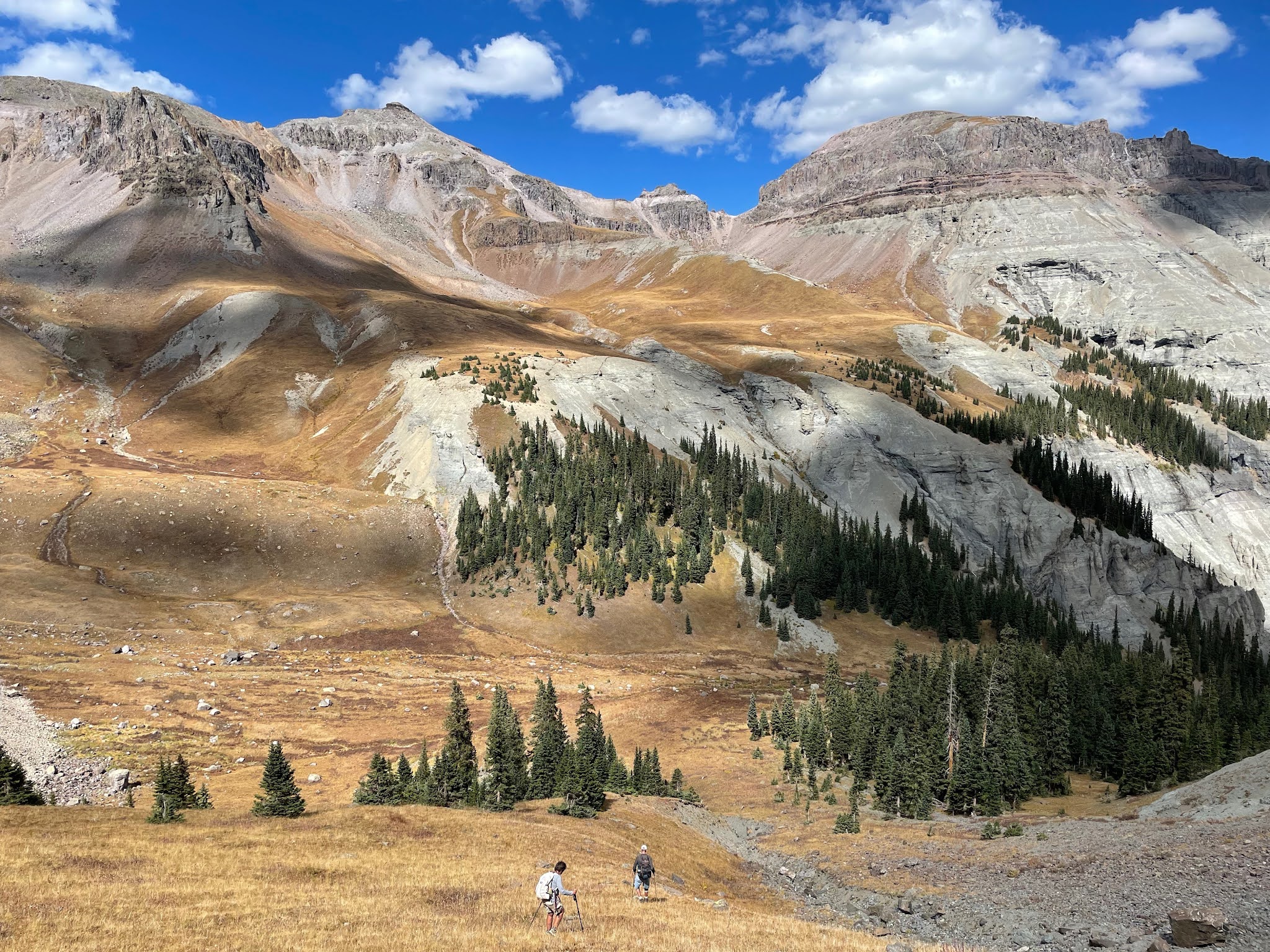
Being a long and elevational one-way hike, we departed early so we could drop a vehicle at the "bottom" trailhead (our destination/end point). Then we drove on up to a point a few miles short of Yankee Boy Basin to begin our hike. The trail—if one could call something so obscure and hit-and-miss a trail—began by winding its way up a significant avalanche chute that's well populated by young aspen saplings, trees still limber enough to withstand violent snow slides that roar down from on high. Older and larger aspen and pine become brittle with age (kinda like us) and get snapped like toothpicks as snow slides sweep down-mountain at speeds known to reach 200 mph.

Though crisp early on, the day blossomed into a beautiful Indian Summer affair. The forecast (if you believe in "fake news) called for morning sun with afternoon clouds moving in. Having already had a few snows higher up, we felt seasonal pressure to get this hike done before Old Man Winter put it off till next year.

We stopped by an old miner's cabin on the way up. While slumping on the outside, it had a few antiquities strung randomly about on the inside.
 |
| Old cookstove...likely used for heating, too. |
 |
| Bobbie digs in her poles on the skinny trail...cut into a steep slope |

 |
| The slope-side gang |

Experienced guides (it was our third or fourth time) helped avoid a few "bumps," things like wrong turns down the wrong drainage (sigh). There are a number of confounding game trails, too, some more traveled than the "right trail" that can lead one (me) offtrack.
We pressed on, cutting up toward the ridge line below and to the right of the rocks in the above photo. And OMG, what a view...
 |
| The "ridge line"and Elk Shit Basin. What campsites...take your pick. |
We decided to rename the above Senator Basin to Elk Shit Basin...mostly because it's chock full of elk shit, and, we've yet to meet a Senator (or anyone, for that matter, which is why we love this hike).
|
| Our route, roughly penciled in. Though the far section is a near vertical climb, tuffs of tundra turn it into a long series of steps. |

Bobbie leans into the slope, while Mike takes in a dramatic view of ragged peaks that soar overhead. A couple hundred feet more and we cut up and left...

...only to top out in a basin that turns out to be a "false summit." We need to trek up one more level to a saddle, the one that drops (and I mean "DROPS") us into yet another bottomless drainage that leads us to our "return vehicle." Whew. 4,000 feet of knee jarring elevation loss.
 |
| View from the "false summit" basin |
 |
| Mike and Chester top out on the "false" basin. To the left and close behind is Bobbie, with a little work left to do. What a view! |
 |
| Mike takes a breather, while Chester waits on "Dad" to get moving. |

After a brutal, near-vertical climb, we ultimately realize the uppermost saddle and break for refreshments. Mike flew his drone, both for our entertainment and to get a bird's eye view of Potosi's summit, to see if there is a safer route to the top than what's apparent from our position on the saddle. We study the scant line of the trail, etched into the hillside till it drops through a rocky vortex that we must soon navigate.
 |
| I always thought the cliffs in the above photo were Potosi. Mikes drone reveals that Potosi actually is hidden behind these cliffs. Another false summit...but from his video footage, it looks like a doable summit route is on the other side. |


 |
| While we were on the saddle having lunch, three hang gliders, catching a good upward draft, soared far overhead |
 |
| Time to start the long trek down...over the saddle and a wild ass slide down steep slopes of bouldered scree. |
 |
| It's a dream back country hike, to just about this point, anyway. Mike and Neighbor "J" have no idea what's coming :). |
 |
| Bobbie surveys the waterfall rockslide for the best way down. This is the "risk" part I mentioned earlier, not necessary, really, but something that gets our "juices" flowing, for sure. These kind of hikes have "numbers" on them. We know that the best way to keep doing them, is to keep doing them. |

 |
| Neighbor J starts down, while Mike launches his drone to get some shots |
 |
| Bobbie finds the best way down. At the very bottom, near the pines, is where we need to go. It's a time consuming descent...occasionally out of control. |
 |
| Views on the way down |
 |
| Bobbie's making great progress...I can't keep up with her, never could! |
 |
| One more slippery slope and we'll be off the scree and marbles. Still, a long way to the car, though (sigh). |

The forecast proved true as cloud puffs began to move in from the west. But the basin is so lovely in "light and shadow," enough to literally blow our minds.

 |
| Though the photo doesn't really show it, the final plunge down tundra is steeper than it looks.s |

The final plunge is blessed tundra. Finally, traction...footing we can trust. The basin valley below eventually funnels us alongside a noisy creek, through both downed and upright trees, always down, down, down, though, then down some more.

Honestly, minutes can feel like hours when toes are raw and quads weak. 4,000 feet is such a long, long descent. But this is the hard work that always seems to be the price of "Glory," and what you must do if you want to keep doing such perverse back country treks.
We hope you enjoyed this foray into Colorado's backcountry.
Peace Out, and remember, Lovely Ouray is now on the cusp of fall. Stay tuned!!!
Also, be sure to check out Mike's drone photography at Ouray By Flight.com. And, be sure to check out "Ohio Peak," Bobbie's new "Old Broads" video. It includes Mike capturing dramatic drone photos and videos from the summit.
Stay tuned...
Mark, Bobbie, Mike, and Neighbor J.
Ah Mark. eye candy for sure. Glad you beat the snows and got another crazy hike in. Makes me shudder to think of sliding down that scree. Bobbie is queen for sure!
ReplyDeleteAbsolutely beautiful country, but there's no way I could have followed you up or down that one! Glad to know brisk walking is just as good for one's health:)
ReplyDeleteGorgeous scenery! Why take a rocket to "space" when you can explore Elk Shit Basin and get an out of this world, out of body experience! Those videos are cool too.
ReplyDeleteI think Terri is Right On; Awesome hike & photos Mark, way to go Bobbie, you deserve a Gold Medal hands down !
ReplyDeleteCan this Blog get any better ? I doubt it....
Stay thirsty my friends
D & A
Fantastic hike and photos, Mark! Nice to get one more in before Winter keeps you out of the high country. :)
ReplyDeleteSheeeesh. 4000 ft down is NO JOKE
ReplyDelete