
When Ruthie, a somewhat new-in-town friend and coworker of Bobbie, mentioned that a couple of gal-friends took her on a long hike up to Ptarmigan Lake and beyond to Imogene Pass, I was impressed. "That's a big day," I said, "must of reached a tad over 13,000 feet."
"Yeah, like 7 hours," came her reply "with lots of steep, loose conditions and a couple wrong turns on the way back."
Huh. To my recollection it was mostly tundraI from the upper basin on, at least the way we did it via Senator Beck Mine.
But I told her Ptarmigan Lake was a favorite of ours then, assuming they used the same route, inquired if they passed the "weather station."
No, I don't think so.
"Senator Beck Mine?"
No...
Did you notice an old mine shack?
No, don't remember that.
Did you start a couple miles up Black Bear Pass Road?
No...we parked just off Highway 550, near Red Mountain Pass.
Was there a trail?
Yes, sometimes, to start, anyway.
Huh. I need to check that out. I'm tired of Senator Beck's route.

Bobbie and I were confused...trying to figure out how "the gals" could have reached Ptarmigan Lake and Imogene on a trail from Red Mountain Pass. I thought we would have known about such a trail.
Then I recalled one time a couple of winters ago when Bobbie and I snowshoed from Red Mountain Pass—just following someone else's tracks off trail to see where they would take us.
The tracks eventually petered out on a steep section, but we pushed on until we recognized a very familiar basin. Turns out we had converged onto the route to Senator Beck Basin trail that started from Black Bear Pass Road.
We turned back due to the route's proximity beneath a heavily loaded north-facing slope. Perhaps that's how the gals went from Red Mountain Pass...instead of going up Black Bear. Then again, if they had, Ruthie would remember the weather station; the trail goes right by it. Beyond that, it would be hard to miss Senator Beck's mine shack, too, set on a wide open slope above timberline. But Ruthie did not recalled seeing either.
Thus I was excited to sleuth out this "new" route to Ptarmigan Lake that, seemingly, by-passed the trailhead to Senator Beck Basin.


If a "picture is worth a thousand words," then the above will save you much reading of my drivel-details about where we were and how we got it so wrong.
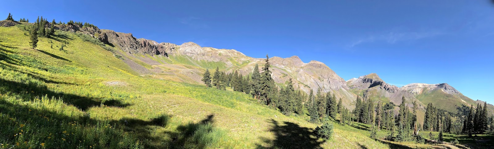
The biggest problem was/is the come and go nature of this little used trail. Then there's the sundry game trails that go off in all directions. That's exactly what led to our getting "cliff-ed out" on a ridge above the "correct" route to Ptarmigan Lake.
 |
| Going the wrong way |
 |
| Looking into Senator Beck Basin from our "cliff-out." Our old old route is down there below Trico Peak, towering majestically over the basin. We almost ran that ridge to the summit a few years ago, but there was too much snow and risk... |

 |
| Bobbie wades the land of tundra...now blond, which means fall has arrived in the high country. |

 |
| Lunch with a view from a dead end knob. |


 |
| Bobbie finds a faint trail (another game-trail) and checks it out... |

Ok, here's the bottom line. While having lunch on our "cliff-out," we spot a come-and-go trail way down in a minor drainage, the one between us and Commodore Gulch.
We checked our map and it soon became obvious that we should have stayed low...followed the stream up, up, up to and beyond the above patches of snow. Then I spotted a trail angling off from above the highest snow patch. Yep. After all that climbing the ridge, we should have stayed in the basin. We were right back where we left off, now staring at another thousand plus feet of climbing. Not today...but next time, at least we'll know how to get to Ptarmigan Lake and Imogene Pass...the hard way.


 |
| Just beyond "The Pond" is where we lost the trail and started climbing... |

It's easy (for me, anyway) to get frustrated at not achieving an objective. Someday soon it won't matter. I'll will surely be crippled (or dead) from all the years of overusing critical joints and ligaments.
So I had to ask myself, why? Why, after a perfect day, having filled in some new dots, climbed thousands of feet and lunched on a far-view cliff with my sweetheart mountain gal/wife, would I feel disappointed? Who could ask for anything more than spending the day as we did? Me thinks only an ingrate. Time to tune up my attitude...
If in the area, feel free to use the above maps and descriptive landmarks to go do some exploring above timberline. There's nothing like it...nothing to block your view except the next mountain over :)
Peace out,
mark and bobbie
Doesn't seem like we have to worry about these adventures every ending and looking at that map only proves there is a whole lot of hiking to be done in them thar San Juans.
ReplyDeleteCan't believe summer has come and gone in the high country, we have been looking for more of those awesome wildflower photos.
Wouldn't it be great if you had another record snow fall this winter again, would be great for the forrest and the folks down stream .
Just put the Plaindealer down before I started this and boy the jeepers are sure going off the roads and down into the gullies this summer, can't imagine what that's like, wonder if they will be back next year to see more mountain top views? :)
From Sonoma Co
Fun map ... there have been times before that I wished for a map pinning the locations of your misadventures. As far as frustration about missed objectives go, I suffer from this as well, and all too often find myself planning routes I'm pretty sure I can complete, challenges I know I can manage. There's cowardice in this, that I recognize, and I'm working on my own attitude adjustment. Security is a seductive trap, as (all of us) grow older.
ReplyDeleteI think it’s great that there are still routes to be discovered right in your backyard. It points out what an incredible backyard you have! Looks like it was a beautiful day in the high country to be on any trail. Chris
ReplyDeleteEven with the wrong turns, it looked like a beautiful hike with gorgeous views. If we were going to get lost out in the San Juans, we would want to make sure it was with you and Bobbie. It would be our only hope of making it out....
ReplyDelete