
I sent out invitations to a few friends to join us for a hike to Bullion King Lake and beyond. Bobbie and I have been itching to try the "beyond" part—up and over the saddle/pass above Bullion King basin—a cross-county search for Columbine Lake. In the ineffable words of Gomer Pyle, "sir-prize, sir-prize, sir-prize;" Nobody responded to my invitation. Maybe it was the vague wording...or the distinct possibility of an endless, high altitude traipse across tundra and scree and boulders that ends with a 911 call...
Bobbie and I prefer "Jello Plans," as opposed to locking into an "itinerary." Some of our best misadventures come as a result of turning left instead of right, on a whim and a prayer. Ultimately, usually after we are back in the safe confines of home or Rv, we celebrate putting a little "wood" on another one Mother Nature's curveballs. The fact is, we enjoy the company of the "Unknowns," enough to have them over a couple times a week.
Most people, however, prefer a little more "structure" to their mountain hikes...you know, things like When will we get back? Where are we going? How many miles is it? Do I need to take a tent and sleeping bag?
Given our track record with Miss Adventure, the lack of enthusiasm is really not surprising. It's hard to address justifiable concerns with any genuine degree of certitude on first go-arounds. Hey, lightening happens. And when cliffed out, have a Cliff Bar.
I do try to be prepared, though, carry a baggie of matches, a (useless) cell phone, and maps...which always seems to get us into more trouble than out. So, once again, we are "Alone again, naturally."
We take Sue Bee, our all-wheel-drive high ground clearance all-terrain vehicle of choice. Sure wish I would have opted for that Extended Warranty...
Just beyond Red Mountain Pass we hang a right on an unmarked 4WD road to the Bullion King Trail Head...above timberline, but below the lake. The road quickly snakes its way above dreaded, dark timber to the heavenly, see-forever sunlit bliss of alpine country.
The road gets a little sketchy, usually due to boulders and whatnot...objects that must be dodged and/or moved out of the way, not to mention the occasional Jeep coming the other direction.
We used to error on the side of prudence and walk the last mile of narrow road. But this time, being dubious regarding time and miles to Columbine Lake, and me with sore legs due to yesterday's Perimeter Trail PR, and, I might add, much to Bobbie's chagrin, I charge ahead to the trailhead parking lot and park beside a Jeeper guy who eyes us with an air of "WTF?"


Wildflowers, for the most part, are stunted...confined to lackluster streams with one tenth normal flows. Away from streams and little patches of melting snow, tundra crunches underfoot...soil serrated with gaping cracks like a dry lakebed.
As smoke billows from the 416 fire north of Durango (70,000 acres and counting) our Rocky Mountain wildflower season dies on the vine. It's too late for monsoons. We have reached a point of no return.


Uncertain of what lies ahead, we don't dawdle at Bullion King Lake. As usual, though, trout dart and play in the shallows of the spillway; What drought?

Pausing for air and a view of T-10, a previous summit, we hear a ruckus amongst the rocks. It sounds a little like pigeons. We finally spot the source. It seems as though we've interrupted a courting pair of ptarmigan.
 |
| The hen is slightly indifferent (sound familiar guys?) |
 |
| The male is identifiable by the bright red slash above its eyes. Note the remaining winter white plumage on his underside. They are nearly impossible to spot on snow during early spring, and then again among rocks during summer when coloring on feathers mimics those of the rocks. |

We are amazed at the amount of green that remains given the parched (scorched?) earth.

 |
A sub-range of the San Juans, the Needle Mountains spike the southern skyline. Substantial peaks include:
|
 |
| Stunted wildflowers |


Rounding a large but nameless mountain, our objective comes into view. Columbine Lake lies at the base of a seemingly distant range, Lookout Mountain being the centerpiece. There is a convenient bench of rock interspersed with tundra that holds elevation change to a minimum (thank you). We follow a well-cairned come and go trail, but must watch carefully as cairns sometimes wander off in all directions.


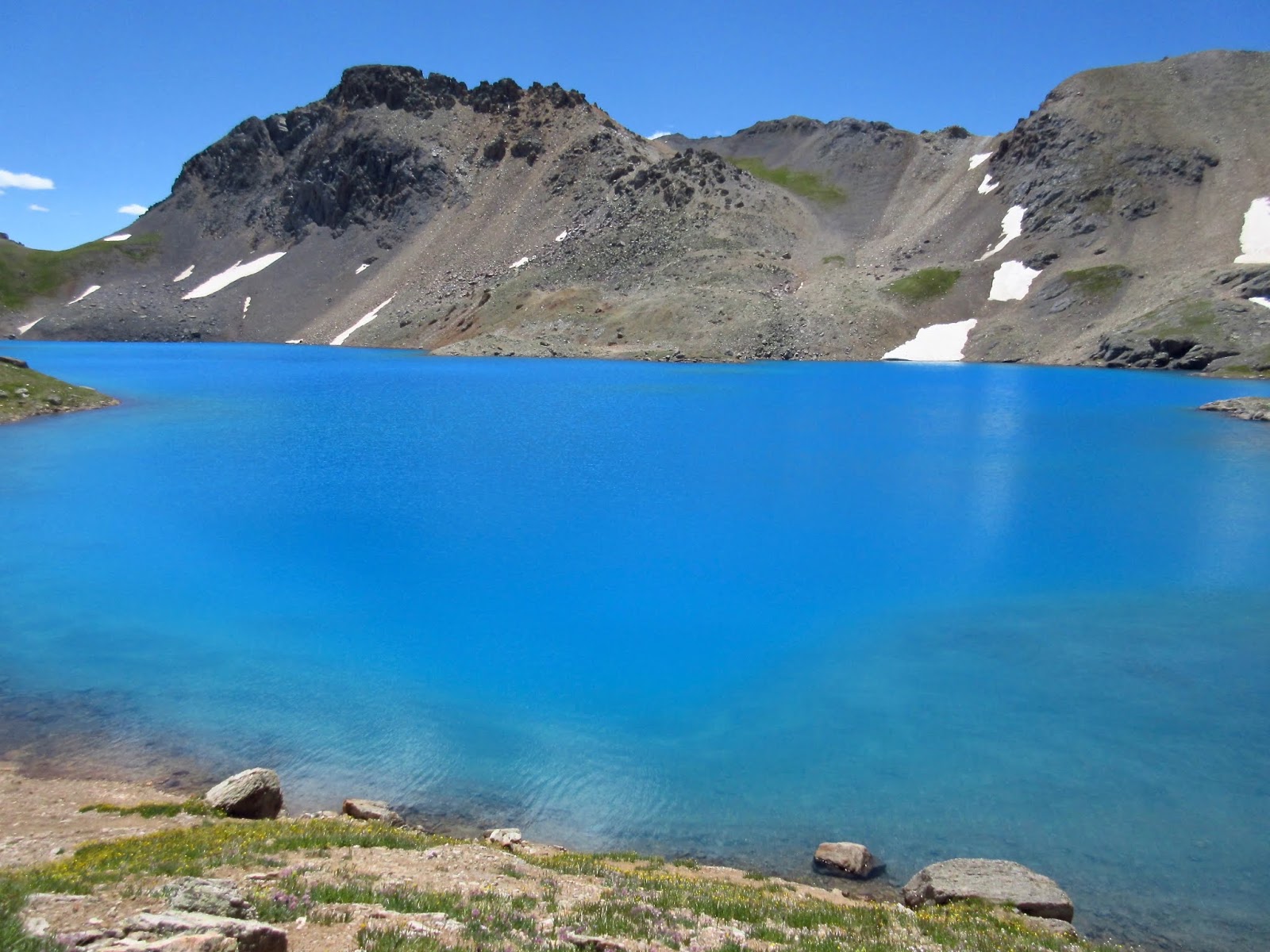
Finally a sliver of blue appears. We got this!

 |
| The saddle centered in the above photo is Oscar Pass. We climbed it last year??? or the year before... expecting a good view of Columbine Lake. But this land is big and contains so many "dots." Well, we should at least be able to see Lewis Lake, we thought, but couldn't find it as lakes tend to form in low spots. But from this ridge line above Columbine Lake and below Lookout Mountain, the "picture" became much more clear and mysteries are resolved. |

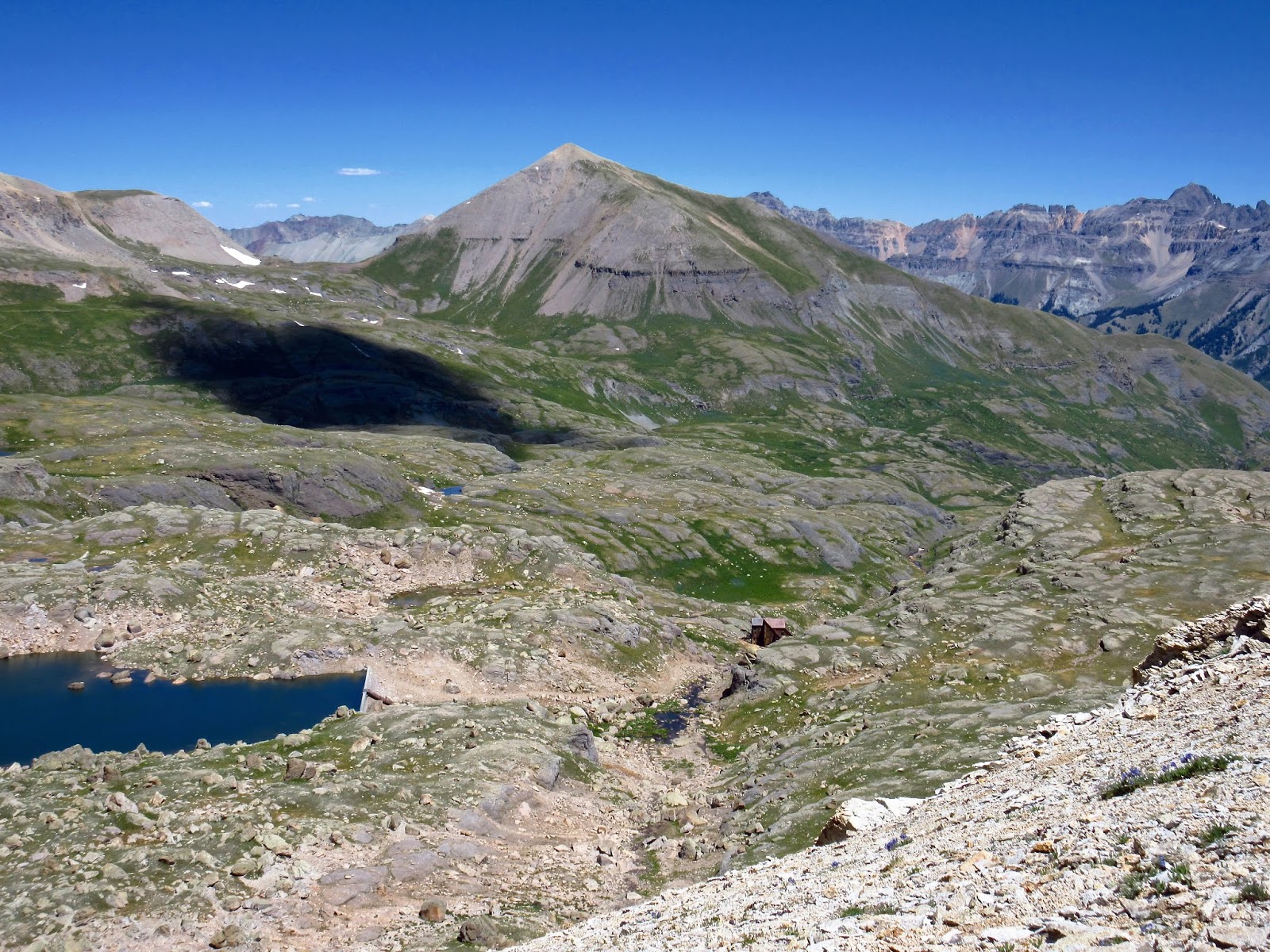 |
| Note the concrete dam for Lewis Lake...and the old, but well preserved, mill below. If one followed the drainage on down below the mill, around and below the centered bald peak, they would land in Telluride. Note the distant highest peak to the far right...Mount Sneffels, 14,150 feet. |
How does one explain the inexplicable to cynical non-believers? You can't. You must show them in person...


 |
| Now I ask you: Do these Geezers look like liars??? |


After almost falling asleep, we decided we best make the long slog back to Bullion King and Sue Bee.


 |
| Red Mountain pops when catching sun amid shadows |
 |
| Another look at Vestal and the Needles... |

While descending to Bullion King Lake, some five hours later, we heard the same ruckus from a horny ptarmigan. The hen seemed to be tired of "the game," as the male clucked and purred and squawked and strutted his "stuff."
Still at it, eh Buddy? I chided knowingly...


Panorama: Scroll Right →

JUST WOW
ReplyDeleteTriple WOW!!! loved the entire adventure, you guys, the blue lake, the hen, etc. thanks for taking me along :)
DeleteTruly amazing blue. You two are as magnificent as that lake! I would never see scenes like this without you.
ReplyDeleteUnbelievably blue!! Gorgeous photos Mark!
ReplyDeleteAwesome !!!
ReplyDeleteIt's a good thing you posted that selfie at the lake, otherwise ....? :)
ReplyDeleteAmazed at all the different types of rock that make up those mountains.
Politics is sure ruining this beautiful Planet and our Lives but then I remember how F&*^ing beautiful are the San Juans and those pains just fade into oblivion : it was great to take this hike with you today, we needed it bad.
Stay thirsty my Friends
Exquisite! I am so envious...
ReplyDeleteI would have loved to join you on that hike, especially with your sore legs :-)
ReplyDeleteThe ptarmigan are so well camouflaged you would have missed seeing them had they not been making noise.
I love the panorama!
Gayle
The many times we have driven that road we have yet to meet another vehicle on it, always with a sigh of relief. It would be a lot of backing to find a place wide enough to pass on it. Even though you have found the wildflowers to be less than spectacular, the colors in the lakes you have visited this year have been gorgeous!
ReplyDeleteIt is extra difficult to read this post as we are sitting in PA with temps in the high 90's and extremely high humidity hiding in the A/C because it is so miserable to be outside. Boy do we miss hitting the trail. Thanks for taking me along on this great trip to the lake. What a big WOW!! That color is unbelievable.
ReplyDeleteHad to get out my Ouray trail map to see the distance between Bullion King Lake and Columbine Lake. Driving up to Bullion 12,500’ was a smart way to see two for one hikes and approach Columbine from a different alpine trail. Those two hikes have to be on my favorite list. 7-17-2012 we hiked Columbine, then 7-20-2012 we hiked Bullion King with Jim and Gayle, Debbie. I will miss seeing you guys this summer but busy watching those grandkids. Need to get a larger RV and bring them out West. Thanks for the great photos.
ReplyDeleteYes, bring the little "Anchors" with you... :)
ReplyDeleteBeautiful, just wish I was close enough to go. I would love to hike those mountains... but as I am sweating like a horse in Arkansas I would have had to wade out into that blue lake!!!
ReplyDeleteThe blue of the lake is almost unbelievable. Did you find any columbines by Columbine Lake? I'm wondering why "blue" isn't in its name...
ReplyDeleteWell, Columbines are usually blue...maybe that's it. We did spot a few :)
Delete